Funny actually, I didn't really consider how it would affect Florida to be cut off from the rest of the US by land. Might be something interesting for someone more educated on the topic to delve into.I like how they didn't want Florida either :v
You are using an out of date browser. It may not display this or other websites correctly.
You should upgrade or use an alternative browser.
You should upgrade or use an alternative browser.
Map Thread XXII
- Thread starter Balkanized U.S.A
- Start date
Kick
My humble personal opinion as somebody who lives in a country that was mostly colonised by Britain in the 19th century is that any surviving British North America which expands past the Mississippi will probably have a lot of subdivisions there defined by boring latitudinal and longitudinal straight lines, just like the IRL US states and territories there. Easier to send out surveyors with equipment for and have them stick to while the area is still in the process of being explored, tamed and settled. If they went to the trouble of doing this in uninviting semidesert on a continent with an inland region much less well-known and traversable than North America's (which has the blessing of navigable waterways and is not the dryest continent on the planet except for Antarctica), I am sure they will be able to do the same in the American interior. Also, it'd be much like actual US surveyors on expeditions did for the OTL US state borders beyond the Appalachians. In both the Australian and American cases the lines came out slightly wonky but were generally straight as intended. Both countries even had court cases over their slightly-wonky internal borders (colonial South Australia vs Victoria, and numerous US states), so the parallels are strong across the Anglosphere.Thanks Devoid.
Well this is the idea that I had in mind. POD would be a fair bit before the actual OTL war.
This we have some original colonies missing/divided. As well as Hispaniola being successfully taken by the British.
But I had no idea on how to divide the lands west of the Mississippi, outside of Texas breaking free from Mexico and joining the Empire.
View attachment 905608
Plus a lot of the 13 colonies had charters theoretically extending their western frontiers all the way to the Pacific Ocean between certain degrees of latitude already, ergo straight lines were the norm. IIRC Virginia claimed, west of the Mississippi, a slice of territory from the 40th Parallel North (current northern Kansas border) down to its southern border extended all the way to California and the Pacific. Obviously we can never really know what the British would truly have done in such a scenario, but would it really be that unrealistic or uncharacteristic of them to detach that and make a long Missouri-Kansas all the way to the Rockies? I imagine these borders will be drawn up in London as well, or with London's approval (as the Galloway Plan of Union, for example, would have required for most peacetime acts of the American government) , like the Australian colonies' borders (defined by latitude, longitude and, to the lesser extent which they exist in Australia, big rivers) were. The only reason I can imagine London not wanting to define distant colonies' boundaries in this manner is if they're still trying to accommodate the slappabitch and kickahoe tribes like they did in 1763, but considering the British have kept North America in this scenario they're probably letting the colonists move west and not annoying them with proclamation lines and intolerable acts that promote the interests of what are, as far as the backcountry white savages from Paxtang and Donegal are concerned, wagon-burners and papist surrender monkeys.
Last edited:
So mostly straight lines with some geographic based borders. Like rivers and mountain ranges, right?My humble personal opinion as somebody who lives in a country that was mostly colonised by Britain in the 19th century is that any surviving British North America which expands past the Mississippi will probably have a lot of subdivisions there defined by boring latitudinal and longitudinal straight lines, just like the IRL US states and territories there. Easier to send out surveyors with equipment for and have them stick to while the area is still in the process of being explored, tamed and settled. If they went to the trouble of doing this in uninviting semidesert on a continent with an inland region much less well-known and traversable than North America's (which has the blessing of navigable waterways and is not the dryest continent on the planet except for Antarctica), I am sure they will be able to do the same in the American interior. Also, it'd be much like actual US surveyors on expeditions did for the OTL US state borders beyond the Appalachians. In both the Australian and American cases the lines came out slightly wonky but were generally straight as intended. Both countries even had court cases over their slightly-wonky internal borders (colonial South Australia vs Victoria, and numerous US states), so the parallels are strong across the Anglosphere.
Plus a lot of the 13 colonies had charters theoretically extending their western frontiers all the way to the Pacific Ocean between certain degrees of latitude already, ergo straight lines were the norm. IIRC Virginia claimed, west of the Mississippi, a slice of territory from the 40th Parallel North (current northern Kansas border) down to its southern border extended all the way to California and the Pacific. Obviously we can never really know what the British would truly have done in such a scenario, but would it really be that unrealistic or uncharacteristic of them to detach that and make a long Missouri-Kansas all the way to the Rockies? I imagine these borders will be drawn up in London as well, or with London's approval (as the Galloway Plan of Union, for example, would have required for most peacetime acts of the American government) , like the Australian colonies' borders (defined by latitude, longitude and, to the lesser extent which they exist in Australia, big rivers) were. The only reason I can imagine London not wanting to define distant colonies' boundaries in this manner is if they're still trying to accommodate the slappabitch and kickahoe tribes like they did in 1763, but considering the British have kept North America in this scenario they're probably letting the colonists move west and not annoying them with proclamation lines and intolerable acts that promote the interests of what are, as far as the backcountry white savages from Paxtang and Donegal are concerned, wagon-burners and papist surrender monkeys.
Quick question: should I paint certain so-called "autonomous capitals" as autonomous regions in their own right?, because for example, I paint present-day OTL maps as showing places like Mexico City, Buenos Aires, Minsk, Yerevan, Bangui, Bissau, London, and Tashkent with the same lighter color of autonomous provinces like Xinjiang in China, and Tatarstan in Russia, but do these cities actually have de-jure autonomy like these autonomous provinces, or not at all?
When capital cities are indicated as "autonomous", its not referring to cultural autonomy for ethnic minorities. It's to indicate that the capital city is of special status, putting it on par with other first-level subdivisions like provinces and states. I'd recommend not coloring capital cities as autonomous regions.
Learned this after posting dozens of maps on this forum with colored "autonomous" capital cities, cheers for the heads up, but one day I might have to update each and every single one of them, this is no problem to me, I just need spare time to do so.When capital cities are indicated as "autonomous", its not referring to cultural autonomy for ethnic minorities. It's to indicate that the capital city is of special status, putting it on par with other first-level subdivisions like provinces and states. I'd recommend not coloring capital cities as autonomous regions.
Burton K Wheeler
Moderator
It’s needlessly inflammatory to say something like “slapabitch and kickahoe tribes”, and you have a history of being needlessly rude, so take a week off.My humble personal opinion as somebody who lives in a country that was mostly colonised by Britain in the 19th century is that any surviving British North America which expands past the Mississippi will probably have a lot of subdivisions there defined by boring latitudinal and longitudinal straight lines, just like the IRL US states and territories there. Easier to send out surveyors with equipment for and have them stick to while the area is still in the process of being explored, tamed and settled. If they went to the trouble of doing this in uninviting semidesert on a continent with an inland region much less well-known and traversable than North America's (which has the blessing of navigable waterways and is not the dryest continent on the planet except for Antarctica), I am sure they will be able to do the same in the American interior. Also, it'd be much like actual US surveyors on expeditions did for the OTL US state borders beyond the Appalachians. In both the Australian and American cases the lines came out slightly wonky but were generally straight as intended. Both countries even had court cases over their slightly-wonky internal borders (colonial South Australia vs Victoria, and numerous US states), so the parallels are strong across the Anglosphere.
Plus a lot of the 13 colonies had charters theoretically extending their western frontiers all the way to the Pacific Ocean between certain degrees of latitude already, ergo straight lines were the norm. IIRC Virginia claimed, west of the Mississippi, a slice of territory from the 40th Parallel North (current northern Kansas border) down to its southern border extended all the way to California and the Pacific. Obviously we can never really know what the British would truly have done in such a scenario, but would it really be that unrealistic or uncharacteristic of them to detach that and make a long Missouri-Kansas all the way to the Rockies? I imagine these borders will be drawn up in London as well, or with London's approval (as the Galloway Plan of Union, for example, would have required for most peacetime acts of the American government) , like the Australian colonies' borders (defined by latitude, longitude and, to the lesser extent which they exist in Australia, big rivers) were. The only reason I can imagine London not wanting to define distant colonies' boundaries in this manner is if they're still trying to accommodate the slappabitch and kickahoe tribes like they did in 1763, but considering the British have kept North America in this scenario they're probably letting the colonists move west and not annoying them with proclamation lines and intolerable acts that promote the interests of what are, as far as the backcountry white savages from Paxtang and Donegal are concerned, wagon-burners and papist surrender monkeys.
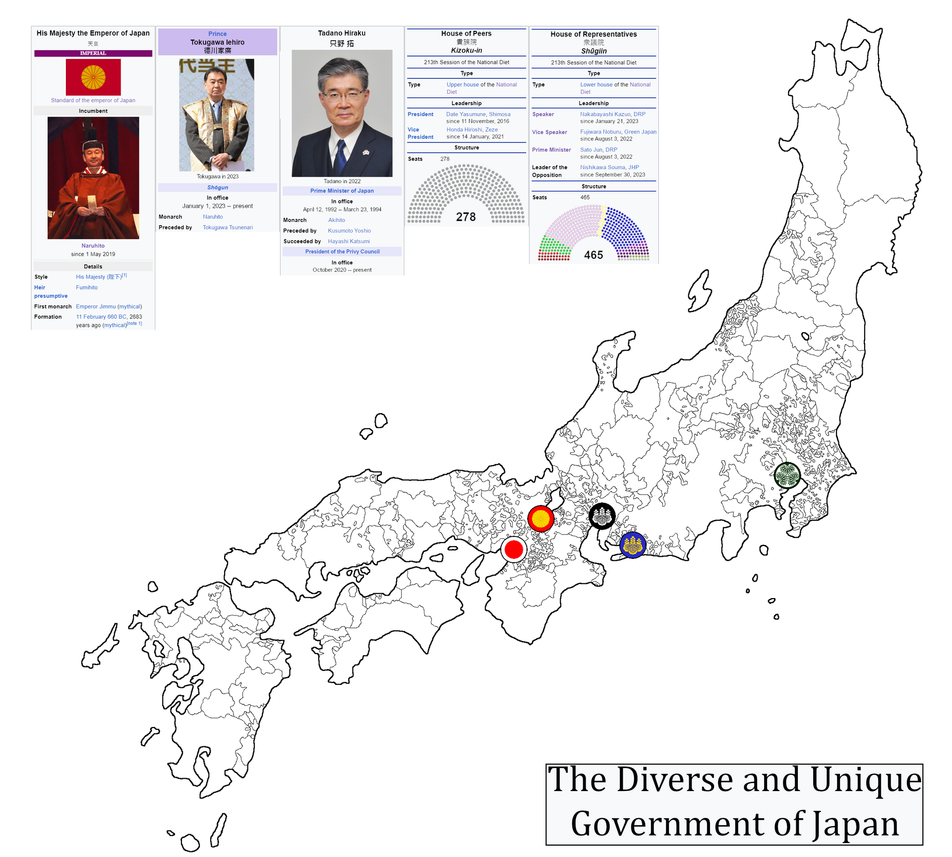
In a world in which Japan just can't quit the Shogun, or the Privy Council, or the House of Peers, as well as still having the Emperor, meaning that they have four ceremonial governing institutions.
Quick explainer
Emperor at top, more religious than anything. De jure head of state. Hereditary
Shogun, de jure appointed by the Emperor, de facto hereditary. De facto head of state, but is also as powerless as the Emperor
Privy Council. Formed during the Shogunate Reformation, acted as advisors to the Shogun before becoming the ruling body in its own right, although that power has since slipped away. Privy councilors and their opinions are still respected as elder statesmen.
House of Peers. Chamber of nobles who get their seat hereditarily and the upper house of the diet. Was the main ruling body in the first half of the 20th century
House of Representatives. Lower house of the diet, members elected democratically. Has been the main ruling body of the country since the mid 20th century.
What are the symbols on the map?
In a world in which Japan just can't quit the Shogun, or the Privy Council, or the House of Peers, as well as still having the Emperor, meaning that they have four ceremonial governing institutions.
Quick explainer
Emperor at top, more religious than anything. De jure head of state. Hereditary
Shogun, de jure appointed by the Emperor, de facto hereditary. De facto head of state, but is also as powerless as the Emperor
Privy Council. Formed during the Shogunate Reformation, acted as advisors to the Shogun before becoming the ruling body in its own right, although that power has since slipped away. Privy councilors and their opinions are still respected as elder statesmen.
House of Peers. Chamber of nobles who get their seat hereditarily and the upper house of the diet. Was the main ruling body in the first half of the 20th century
House of Representatives. Lower house of the diet, members elected democratically. Has been the main ruling body of the country since the mid 20th century.
My guess is the seat of each institution.What are the symbols on the map?
What are the symbols on the map?
Yeah, this. Imperial symbol in Kyoto is for the Emperor, the Tokugawa Mon in Edo/Tokyo is for the Shogun, the Black-and-white Toyotomi symbol in Nagoya is for the House of Peers, the Blue-and Gold Toyotomi seal in Toyohashi for the Privy Council, and the Hinomaru in Osaka for the House of Representatives.My guess is the seat of each institution.
You know, adding 5 capitals just to add to the "uniqueness" of Japan here
Last edited:
So Nagoya, Toyohashi, and Osaka if I'm reading the map correctly?Yeah, this. Imperial symbol in Kyoto is for the Emperor, the Tokugawa Mon in Edo/Tokyo is for the Shogun, the Black-and-white Toyotomi symbol is for the House of Peers, the Blue-and Gold Toyotomi seal for the Privy Council, and the Hinomaru for the House of Representatives.
You know, adding 5 capitals just to add to the "uniqueness" of Japan here
Yes, sorry I had already forgotten to write the names of the cities by the thirdSo Nagoya, Toyohashi, and Osaka if I'm reading the map correctly?
Very nice, a unique touch and I like it very muchYeah, this. Imperial symbol in Kyoto is for the Emperor, the Tokugawa Mon in Edo/Tokyo is for the Shogun, the Black-and-white Toyotomi symbol in Nagoya is for the House of Peers, the Blue-and Gold Toyotomi seal in Toyohashi for the Privy Council, and the Hinomaru in Osaka for the House of Representatives.
You know, adding 5 capitals just to add to the "uniqueness" of Japan here

What happened to Hokkaido?
In a world in which Japan just can't quit the Shogun, or the Privy Council, or the House of Peers, as well as still having the Emperor, meaning that they have four ceremonial governing institutions.
Quick explainer
Emperor at top, more religious than anything. De jure head of state. Hereditary
Shogun, de jure appointed by the Emperor, de facto hereditary. De facto head of state, but is also as powerless as the Emperor
Privy Council. Formed during the Shogunate Reformation, acted as advisors to the Shogun before becoming the ruling body in its own right, although that power has since slipped away. Privy councilors and their opinions are still respected as elder statesmen.
House of Peers. Chamber of nobles who get their seat hereditarily and the upper house of the diet. Was the main ruling body in the first half of the 20th century
House of Representatives. Lower house of the diet, members elected democratically. Has been the main ruling body of the country since the mid 20th century.
Hokkaido just was never colonized in this world, and instead exists as an independent Ainu stateWhat happened to Hokkaido?
Share: